


tunnel du roux chaumienne

raab
User
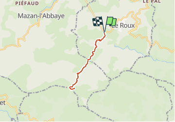

Length
9.6 km

Max alt
1303 m

Uphill gradient
496 m
Km-Effort
16.2 km

Min alt
955 m

Downhill gradient
497 m
Boucle
Yes
Creation date :
2021-04-21 12:35:34.031
Updated on :
2021-04-21 12:38:49.689
2h03
Difficulty : Easy

FREE GPS app for hiking
 SityTrail
IGN / Geographical institutes
SityTrail Plus
The world is yours!
About
Trail On foot of 9.6 km to be discovered at Auvergne-Rhône-Alpes, Ardèche, Le Roux. This trail is proposed by raab.
Positioning
Country:
France
Region :
Auvergne-Rhône-Alpes
Department/Province :
Ardèche
Municipality :
Le Roux
Location:
Unknown
Start:(Dec)
Start:(UTM)
589864 ; 4952484 (31T) N.
Comments